 According to an old Ho-Chunk legend, the Wisconsin River was formed by a manitou, or spirit, who had taken the form of a gigantic serpent. One day he decided to make a trip to the sea from his home in the great forests near Big Lake. As he crawled over the land he made a groove into which water rushed. Sudden movements of his tail caused the water to splash and form lakes. The beds of the tributaries arose from the grooves to other serpents who, being afraid of the great spirit, had fled in all directions. Near the Dells the serpent entered a large body of rock. Finding a crack, he thrust his head in and struggled forward, bursting the stone apart as he went. Further on he changed direction and, becoming tired from his efforts, he rested and wallowed around, which widened the channel there.
In some ways the scientific explanation of the river’s origin is not so satisfying as the Native Americans' magical story. Fettered by facts and theories, geologists have a more difficult job, for to decipher the river’s development requires going back several billion years almost to the basement of time – the Precambrian era. Accordingly, their interpretation of its formative history is complex and not completely understood or even agreed upon. Much of this uncertainty has to do with glacial events in northern and south-central Wisconsin that rewrote the script – obliterating earlier land forms and creating new ones. These events are what caused the river to assume its present unusual course: bisecting the state vertically for the first two-thirds of its length, bending to the west between Stevens Point and Wisconsin Rapids, and then below Portage abruptly turning westward until emptying into the Mississippi.
The current thinking is that with the exception of the Driftless Area in southwestern Wisconsin, different portions of the state were covered with ice by at least one and possibly as many as twenty-five glacial advances, which came down from Canada in a period between about 2.4 million and 25,000 years ago. Insights into their history are just unfolding. Finally, about twenty-five thousand years ago a lobe of the last great glacier of the Ice Age flowed southwesterly across the state until it covered the northern portion to about Merrill. Another part of this ice sheet – commonly called the Great Bay Lobe – extended southerly from near Antigo to the east end of the Baraboo Hills, then southwesterly through Dane County and into northern Illinois.
The intersection of this glacier with the unyielding Baraboo Hills created an ice dam that impounded the glacier’s meltwaters and formed a huge body of water called Glacial Lake Wisconsin. Probably this dam broke and reformed several times as the ice front alternatively wasted back and advanced over the next several thousand years. At its zenith, the lake covered an area in the central portion of the state estimated to have been more than eight times larger than Lake Winnebago and with depths of up to 160 feet.
About fourteen thousand years ago, the ice sheet began permanently withdrawing as the earth’s atmosphere warmed toward the end of the Pleistocene, and the Baraboo Hills’ ice dam broke for the final time. The cataclysmic flood that ensued literally compressed geological time into hours – the lake’s water level probably dropped a hundred feet in several days as its rampaging waters tore out a channel and flooded down the lower Wisconsin River valley, swelling the river to over a hundred times its present size. Enormous quantities of sand and gravel filled the river’s bed, in some areas up to 150 feet deep. Later as the stream eroded through it, numerous terraces were formed.
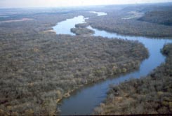
Because of these events, the present-day riverbed consists of four major segments, each with a distinctive history. The first segment from Lac Vieux Desert to Merrill formed while the last glacial advance receded from this area. Since the land from Merrill to Stevens Point was not covered at that time by either ice or Glacial Lake Wisconsin, this segment of the riverbed predates the last glacier. It probably served to carry melt-water from the ice front to the glacial lake. The third segment from Stevens Point to Portage was formed when the glacial lake drained. (Below Stevens Point, the pre-glacial river’s course had been to the southeast but it was still blocked by the receding glacier when the ice dam broke.) The river’s course around Portage formed soon after the ice dam broke when the river was forced to cut a new channel at a lower elevation. The last segment, west to the Mississippi, had probably been part of another older river whose origin to the east had been erased by the glacier. Interestingly, at some much earlier time – perhaps as early as the first advance about 2.4 million years ago – a glacier had penetrated two to three miles up this river’s mouth, temporarily forcing it to flow eastward, likely by way of the Duck Creek and Fox River drainages to an ancestral Rock River system.
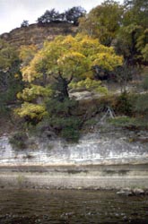
 From its origin at Lac Vieux Desert, the river flows through the northern highlands to Nekoosa, a province of ancient Precambrian crystalline bedrocks overlaid by layers of drift from several major glacial advances. Just above Merrill the river crosses the youngest glacier’s terminal moraine (i.e., rocky deposits marking the termination of a glacial advance). From Merrill it continues south through older glacial drift, traversing a major moraine by the Lake DuBay dam in northern Portage County and passing through the oldest drift until it reaches Stevens Point. Here it leaves the glaciated area, and below the city turns westward to Wisconsin Rapids – Nekoosa, imprisoned between the edge of the oldest glacier’s moraine to the north and the youngest glacier’s outwash plain to the south. Just beyond Nekoosa, it abruptly passes into the Cambrian sandstone lowlands, entering the flat Central Sand Plain – a legacy of Glacial Lake Wisconsin. About a mile below the Dells, it crosses another portion of the youngest glacier’s terminal moraine and flows through its drift until it reaches Prairie du Sac, where it recrosses the moraine. The river then traverses the uplifted, soft sandstones and limestones of the Driftless Area in the Western Uplands until it joins the Mississippi.
